


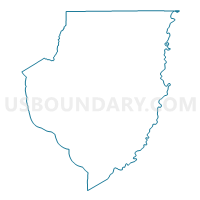
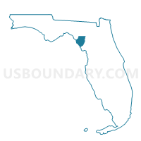
1A-Voting District, Dixie County, Florida
About
Outline

Summary
| Unique Area Identifier | 552707 |
| Name | 1A-Voting District |
| County | Dixie County |
| State | Florida |
| Area (square miles) | 0.12 |
| Land Area (square miles) | 0.08 |
| Water Area (square miles) | 0.03 |
| % of Land Area | 71.45 |
| % of Water Area | 28.55 |
| Latitude of the Internal Point | 29.82266900 |
| Longtitude of the Internal Point | -82.91178330 |
Maps

Graphs
Select a template below for downloading or customizing gragh for 1A-Voting District, Dixie County, Florida


Neighbors
Neighoring Voting District (by Name) Neighboring Voting District on the Map
Top 10 Neighboring County Subdivision (by Population) Neighboring County Subdivision on the Map
- Cross City North CCD, Dixie County, FL (12,321)
- Mayo CCD, Lafayette County, FL (5,706)
- Bell CCD, Gilchrist County, FL (5,358)
Top 10 Neighboring Unified School District (by Population) Neighboring Unified School District on the Map
- Gilchrist County School District, FL (16,939)
- Dixie County School District, FL (16,422)
- Lafayette County School District, FL (8,870)
Top 10 Neighboring State Legislative District Lower Chamber (by Population) Neighboring State Legislative District Lower Chamber on the Map
Top 10 Neighboring State Legislative District Upper Chamber (by Population) Neighboring State Legislative District Upper Chamber on the Map
Top 10 Neighboring 111th Congressional District (by Population) Neighboring 111th Congressional District on the Map
Top 10 Neighboring Census Tract (by Population) Neighboring Census Tract on the Map
- Census Tract 9701.02, Dixie County, FL (7,331)
- Census Tract 9602, Lafayette County, FL (5,706)
- Census Tract 9501, Gilchrist County, FL (5,358)